Welcome to WordPress. This is your first post. Edit or delete it, then start writing!
1896 Berea by Frost and Hayes
According to David Walls, William Goodell Frost, President of Berea College from 1892 to 1920, was “the first person to give a precise geographic definition to the Southern Appalachians as a cultural region” with the help of his former student, C. Willard Hayes, “then working for the Geological Survey.”
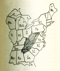
Though Frost’s text indicated that the region was 194 counties, county boundaries have shifted since 1896. Our ArcGIS recreation includes 195 counties as our best approximation of Frost’s hand-drawn map.
Map Links
1895 to 1901 – Berea Hypothetical Region
View Online | Download Shapefile | Static Map
1917 – Physiographic Provinces
View Online | Download Shapefile | Static Map
1918 – Berea Region
View Online | Download Shapefile | Static Map
1921 – John C. Campell’s Region
View Online | Download Shapefile | Static Map
1935 – USDA small region
View Online | Download Shapefile | Static Map
1935 – USDA full region
View Online | Download Shapefile | Static Map
1940 – Works Progress Administration – Rural Cultural Region “Allegheny”
View Online | Download Shapefile | Static Map
1940 – Works Progress Administration – Rural Cultural Region “Appalachia”
View Online | Download Shapefile | Static Map
1940 – Works Progress Administration – Rural Farm Cultural Region
“Allegheny”
View Online | Download Shapefile | Static Map
1940 – Works Progress Administration – Rural Farm Cultural Region
“Appalachia”
View Online | Download Shapefile | Static Map
1962 – Ford region
View Online | Download Shapefile | Static Map
1964 – PARC
View Online | Download Shapefile | Static Map
1965 – Original ARC Region
View Online | Download Shapefile | Static Map
1965 – ARC second iteration
View Online | Download Shapefile | Static Map
1967 ARC
View Online | Download Shapefile | Static Map
1978 – Watts Mountain Terrain
View Online | Download Shapefile | Static Map
1978 – Watts Socioeconomic Region
View Online | Download Shapefile | Static Map
1978 – Watts Homogeneous Region
View Online | Download Shapefile | Static Map
1983 – Raitz and Ulack Region
View Online | Download Shapefile | Static Map
1990 – ARC
View Online | Download Shapefile | Static Map
1991 – ARC
View Online | Download Shapefile | Static Map
1994 – Paul Salstrom’s Region
View Online | Download Shapefile | Static Map
1998 – ARC
View Online | Download Shapefile | Static Map
2002 – ARC
View Online | Download Shapefile | Static Map
2008 – ARC
View Online | Download Shapefile | Static Map
2002 – Core Region from John Alexander Williams
View Online | Download Shapefile | Static Map
1996 – Consensus Region from John Alexander Williams
View Online | Download Shapefile | Static Map
1996 – Loose Region from John Alexander Williams
View Online | Download Shapefile | Static Map